

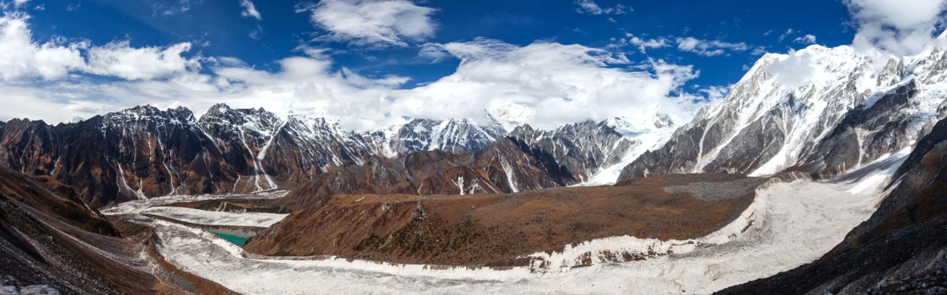
Manaslu Tsum Valley Trek – 22 Days Through the Hidden Himalayan Valleys of Nepal
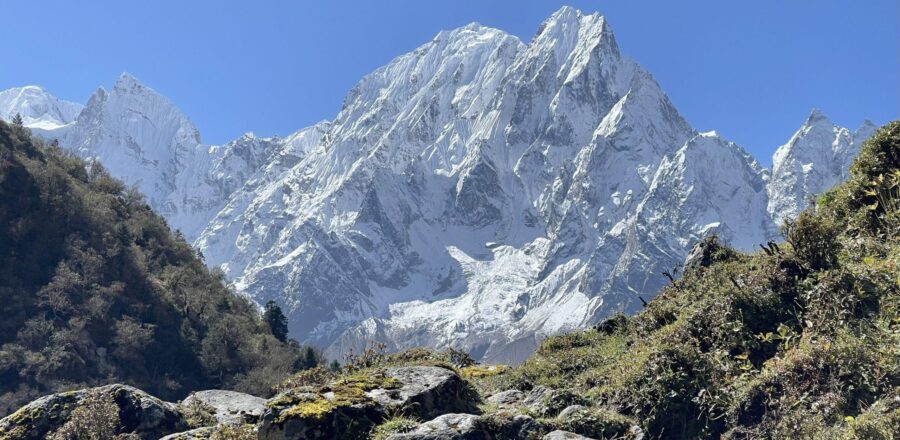
استخدم رحلة تريك إلى وادي ماناسلو تسوم is a journey for travellers who want to experience a quieter and more remote side of the Nepal Himalayas.
Far from the busy trails of the Everest and Annapurna regions, this trek leads through the dramatic landscapes surrounding Mount Manaslu, traditional Gurung villages, ancient Buddhist monasteries, narrow mountain gorges and the culturally rich Tsum Valley.
What makes this journey particularly special is the contrast between its different sections. The trail begins with the rushing Budi Gandaki River and green hills before gradually moving into higher, colder and more rugged terrain. In the Tsum Valley, the atmosphere changes again, with Tibetan Buddhist traditions, centuries-old monasteries and isolated settlements surrounded by high Himalayan peaks.
The journey eventually continues towards Samagaon and Manaslu Base Camp before reaching its highest point at لاركيا لا باس على ارتفاع 5,160 متر. From there, the trail descends through Bhimtang, Tilje and Dharapani before returning towards Kathmandu.
هذه 22-day Manaslu Tsum Valley Trek is not simply about reaching one destination. It is a long Himalayan journey through changing landscapes, cultures and elevations, with every section offering something different.
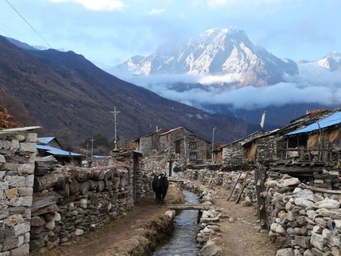
أبرز معالم رحلة وادي ماناسلو تسوم
- Explore the remote and culturally rich Tsum Valley
- Trek through traditional Gurung and Tibetan-influenced villages
- Experience the dramatic Budi Gandaki Valley
- Visit Milarepa Piren Phu Cave
- Explore Mu Gompa and Dhephu Gompa
- Visit Rachen Gompa
- Experience the mountain villages of Chumling, Chhokangparo and Nile
- Explore Samagaon and the upper Manaslu region
- رحلة إلى معسكر قاعدة ماناسلو
- Visit Birendra Lake
- Cross the challenging Larkya La Pass
- Reach the highest point of the trek at 5,160 metres
- Enjoy views of Manaslu, Himalchuli, Ganesh Himal, Himlung, Annapurna II and surrounding peaks
- Walk through rhododendron and pine forests
- Experience remote Himalayan communities away from the busier trekking routes
- Private group discounts available
Manaslu Tsum Valley Trek at a Glance
| تفاصيل الرحلة | معلومات |
|---|---|
| المدة | 22 أيام |
| المنطقة | Manaslu & Tsum Valley |
| أقصى ارتفاع | 5,160 م / 16,929 قدم |
| أعلى نقطة | ممر لاركيا لا |
| نقطة انطلاق الرحلة | ماشا خولا |
| Trek Ending Point | داراباني |
| أبرز النقاط | معسكر قاعدة ماناسلو |
| Tsum Valley Highlight | Mu Gompa & Milarepa Cave |
| صعوبة | تحدي |
| الإقامة | Hotels & Mountain Guest Houses |
| أسلوب الرحلات | رحلة بصحبة مرشد |
| نوع المجموعة | خاص / مجموعة |
| أفضل المواسم | الربيع والخريف |
 Why Choose the Manaslu Tsum Valley Trek?
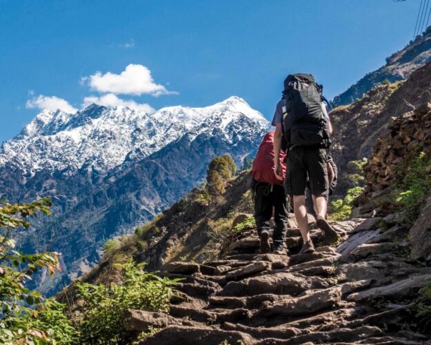
استخدم رحلة تريك إلى وادي ماناسلو تسوم is ideal for trekkers looking beyond Nepal’s popular routes and wanting a deeper Himalayan experience. This 22-day adventure combines remote mountain scenery, authentic Tibetan Buddhist culture, traditional villages, ancient monasteries, and the challenging Larkya La Pass.
- Remote & Less Crowded: Experience peaceful trails far from Nepal’s busiest trekking routes.
- Two Treks in One: Explore the mystical Tsum Valley before continuing through the spectacular Manaslu Circuit.
- الثقافة التبتية الغنية: Discover centuries-old monasteries, prayer walls, chortens and traditional Himalayan communities.
- Exceptional Mountain Views: Enjoy dramatic views of Manaslu, Ganesh Himal, Himalchuli and other Himalayan peaks.
- Mu Gompa Experience: Visit the remote and culturally significant Mu Gompa in the upper Tsum Valley.
- Larkya La Adventure: عبور الشهير 5,106-meter Larkya La Pass surrounded by impressive high-altitude scenery.
- قرى جبال الهيمالايا الأصيلة: Stay in local teahouses and experience the traditional lifestyle of mountain communities.
- مناظر طبيعية متنوعة: Trek through lush forests, river valleys, alpine terrain, glacial landscapes and high mountain passes.
- مثالي لمحبي المغامرة: A rewarding combination of cultural discovery, wilderness, high-altitude trekking and Himalayan exploration.
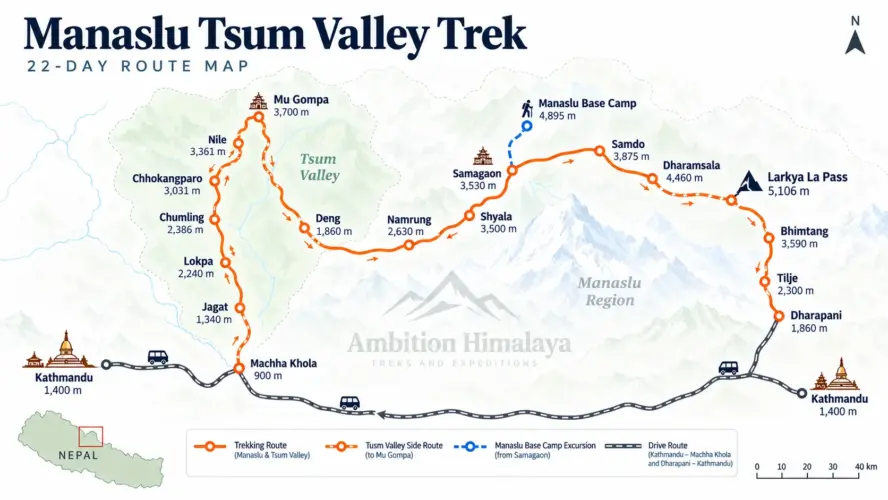
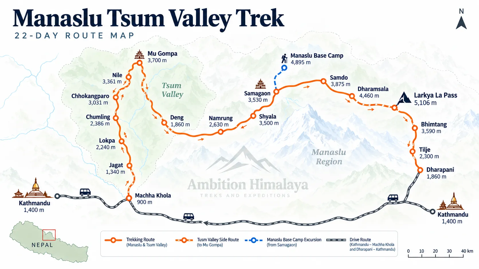
22-Day Manaslu Tsum Valley Trek Itinerary
اليوم الأول: الوصول إلى كاتماندو
ارتفاع: 1,350 م
الإقامة: فنادق
وجبة: عشاء
إن رحلة تريك إلى وادي ماناسلو تسوم begins in Kathmandu.
After arriving at Tribhuvan International Airport, our representative will meet you at the terminal and transfer you to your hotel.
Once you have settled in, you can rest after your journey or take a short walk around the neighbourhood.
The evening is kept relaxed, with time to meet the trekking team and prepare mentally for the adventure ahead.
A welcome dinner gives you an opportunity to experience traditional Nepali food before the trek begins.
اليوم الثاني: يوم حر والاستعداد للرحلة في كاتماندو
ارتفاع: 1,350 م
الإقامة: فنادق
الوجبات: الإفطار والغداء
Before heading into the mountains, you have a preparation day in Kathmandu.
This is the time to check your trekking equipment, organise your backpack and make sure you have the essentials required for the journey.
Important trekking equipment includes good trekking boots, trekking poles, layered clothing, warm gloves, a warm sleeping bag, sunglasses, sunscreen, a sun hat, water purification supplies and personal medication.
You can also use part of the day to explore Kathmandu before the long trek begins.
A little preparation today can make a big difference once you are several days into the mountains.
Day 3: Drive from Kathmandu to Machha Khola
المسافات: ما يقرب من 160 كم
الإقامة: دار الضيافة
الوجبات: فطور غداء عشاء
Today you leave Kathmandu by road and travel towards Machha Khola, the starting point of the trekking section.
The journey takes you away from the busy capital and into the countryside.
The route initially follows the Prithvi Highway before turning towards the northern valleys. Along the way, you pass through areas including Dhading Besi and Aarughat before continuing towards Machha Khola.
The scenery gradually changes from urban surroundings to terraced farmland, forested hills and river valleys.
Machha Khola is the final major settlement before the trek begins in earnest.
Overnight at a local guest house.
اليوم الثاني: من ماشا خولا إلى جاغات
المسافات: ما يقرب من 21 كم
المشي: 6 - 7 ساعة
الإقامة: دار الضيافة
الوجبات: فطور غداء عشاء
Today marks your first full trekking day.
The trail follows the Budi Gandaki River through a landscape of green hills, rocky paths and traditional villages.
You pass Khorlabesi and continue towards Tatopani, where natural hot springs provide an interesting stop along the route.
The trail then continues towards Dobhan and Yaru Bagar, involving several ascents, descents and suspension bridge crossings.
Eventually, you reach Jagat, a traditional Gurung settlement at around 1,340 metres.
Jagat is an important point on the Manaslu trekking route and provides your first real feeling of being inside the Himalayan trail network.
Day 5: Jagat to Lokpa
المسافات: ما يقرب من 18 كم
المشي: 6 - 7 ساعة
ارتفاع: 2,240 م
الإقامة: دار الضيافة
الوجبات: فطور غداء عشاء
The trail begins climbing more noticeably today.
Leaving Jagat, you follow the Budi Gandaki upstream through farmland and small settlements before reaching Ekle Bhatti.
From there, the landscape becomes increasingly rugged.
The route passes through a narrow gorge before reaching Philim. After Philim, the trail enters forested terrain dominated by rhododendron and pine.
This section feels considerably more isolated than the earlier part of the trek.
After several hours of walking through forest and mountain terrain, you arrive at Lokpa.
Day 6: Lokpa to Chumling
المسافات: ما يقرب من 8 كم
المشي: حول ساعات شنومك
ارتفاع: 2,386 م
الإقامة: دار الضيافة
الوجبات: فطور غداء عشاء
Today is a shorter trekking day, giving you time to enjoy the changing landscape.
The trail descends towards the Lungwa River before continuing through lush pine and rhododendron forests.
After crossing a suspension bridge, the route climbs towards Gumling.
From here, you can enjoy views towards Ganesh Himal and Baudha Himal.
The trail continues through a series of climbs and descents before crossing the Syar Khola and reaching Chumling, also known as Lower Chum.
The village provides your first deeper introduction to the unique culture of the Tsum Valley.
Day 7: Chumling to Chhokangparo
المسافات: ما يقرب من 10 كم
المشي: 5 - 6 ساعة
ارتفاع: 3,010 م
الإقامة: دار الضيافة
الوجبات: فطور غداء عشاء
The trail continues deeper into the Tsum Valley.
Following the Syar Khola, you walk through pine woodland towards Domje, one of the larger settlements in the lower Tsum Valley.
The route then continues towards Gho, where you can visit a local gompa before continuing uphill.
The final part of the day involves a gradual ascent to Chhokangparo, also known as Upper Chum.
As you gain altitude, the mountain scenery becomes increasingly impressive, with views towards Himalchuli and Ganesh Himal.
Day 8: Chhokangparo to Nile via Milarepa Piren Phu Cave
المسافات: ما يقرب من 10 كم
المشي: 4 - 5 ساعة
ارتفاع: حوالي 3,500 م
الإقامة: دار الضيافة
الوجبات: فطور غداء عشاء
One of the cultural highlights of the رحلة تريك إلى وادي ماناسلو تسوم awaits today.
The trail leads towards Lamagaon and then to the famous Milarepa Piren Phu Cave.
According to local Buddhist tradition, the cave is associated with the great Tibetan Buddhist master Milarepa, who is believed to have meditated here.
The cave and surrounding religious sites provide a fascinating glimpse into the spiritual history of the valley.
After exploring the area, you continue through Phurbe, Pang and Chhule before crossing the Syar Khola and reaching Nile.
The landscape is increasingly high-altitude now, with traditional villages surrounded by barren Himalayan slopes.
Day 9: Nile to Mu Gompa and Hike to Dhephu Gompa
Mu Gompa: حوالي 3,700 مترًا
Dhephu Gompa: حوالي 4,060 مترًا
المشي: 2.5–3 hours to Mu Gompa + day hike
الإقامة: دار الضيافة
الوجبات: فطور غداء عشاء
Today’s journey is shorter in distance but rich in cultural and spiritual experiences.
From Nile, the trail follows the Syar Khola towards Mu Gompa.
The gradual climb passes chortens and traditional Buddhist features before reaching the remote monastery settlement.
After checking into the accommodation, you continue with a day hike towards Dhephu Gompa.
Situated at a higher elevation, Dhephu Gompa offers a quiet mountain setting and an opportunity to experience the spiritual atmosphere of this remote part of the Himalayas.
After the hike, return to Mu Gompa for the night.
Day 10: Nile to Chumling
المسافات: ما يقرب من 18 كم
المشي: 6 - 7 ساعة
ارتفاع: 2,386 م
الإقامة: دار الضيافة
الوجبات: فطور غداء عشاء
The route now begins its return through the Tsum Valley.
You descend alongside the Syar Khola towards Chhule before continuing towards Rachen Gompa.
Rachen Gompa is an important Buddhist nunnery in the valley and offers another opportunity to experience the religious heritage of the region.
After visiting the area, the trail continues towards Pang and Phurbe before reaching Lamagaon.
From Lamagaon, you continue downhill towards Chumling.
The lower elevation becomes noticeable as the air grows warmer and the vegetation becomes thicker.
Day 11: Chumling to Deng
المسافات: ما يقرب من 19 كم
المشي: حول ساعات شنومك
ارتفاع: 1,860 م
الإقامة: دار الضيافة
الوجبات: فطور غداء عشاء
Leaving Chumling, the trail descends through forested terrain towards Lokpa.
After reaching Lokpa, the route continues along the Syar Khola.
The landscape is filled with forest, river valleys and dramatic mountain slopes, with views towards Sringi Himal.
You cross Ghatta Khola before beginning the final section towards Deng.
Deng sits at a considerably lower elevation than the villages you have recently visited, making the change in climate noticeable.
اليوم السابع: من دينج إلى نامرونج
المسافات: ما يقرب من 19 كم
المشي: 7 + ساعات
ارتفاع: 2,630 م
الإقامة: دار الضيافة
الوجبات: فطور غداء عشاء
The trail climbs again today.
After crossing the Budi Gandaki River, you continue towards Rana and Bihi.
Waterfalls, forests and mountain scenery accompany much of the route.
The trail then reaches Ghap, where chortens and mani walls begin to appear more frequently.
From Ghap, it takes roughly another hour and a half to reach Namrung.
Namrung marks another important transition point as the landscape begins to take on a more alpine character.
اليوم السادس: من نامرونغ إلى شيالا
المسافات: ما يقرب من 10 كم
المشي: حول ساعات شنومك
الإقامة: دار الضيافة
الوجبات: فطور غداء عشاء
After yesterday’s long walking day, today’s route is shorter but involves a significant climb.
The trail leaves Namrung and gradually ascends through oak forest towards Sho.
Continuing higher, you reach Lho, a culturally important village known for دير ريبونغ.
The monastery provides both cultural interest and beautiful views towards the Manaslu range.
From Lho, the trail continues across wider mountain paths before reaching Shyala.
The views become increasingly dramatic as the surrounding peaks begin to dominate the skyline.
Day 14: Shyala to Samagaon via Pungyen Gompa
المسافات: ما يقرب من 17 كم
المشي: 4 - 5 ساعة
أقصى ارتفاع: حوالي 4,050 مترًا
الإقامة: دار الضيافة
الوجبات: فطور غداء عشاء
Today brings you into the high Manaslu landscape.
Leaving Shyala, you walk through open grassland and thin woodland before reaching the junction towards Pungyen Gompa.
The trail leads towards yak pastureland where you can enjoy wide views across the surrounding mountains.
Pungyen Gompa sits in an impressive setting and is an important cultural stop on the route.
After exploring the area, the trail descends before continuing towards Samagaon.
At around 3,530 metres, Samagaon is one of the most important settlements in the upper Manaslu region.
Day 15: Samagaon to Manaslu Base Camp and Return
Manaslu Base Camp: حوالي 4,800 مترًا
المسافات: رحلة ذهاب وعودة تبلغ حوالي 12 كيلومترات
المشي: حول ساعات 7
الإقامة: دار الضيافة
الوجبات: فطور غداء عشاء
Today is one of the major highlights of the entire trek.
From Samagaon, you begin the climb towards معسكر قاعدة ماناسلو.
The trail initially climbs gradually towards Birendra Lake before becoming more rugged.
As you move higher, the terrain changes to rocky paths, small streams and increasingly barren mountain surroundings.
After several hours of climbing, you reach Manaslu Base Camp.
The enormous Manaslu massif rises above the valley, creating an unforgettable Himalayan panorama.
After spending time at Base Camp, you retrace your steps and return to Samagaon for the night.
اليوم السابع: من ساماجاون إلى سامدو
المسافات: ما يقرب من 9 كم
المشي: حول ساعات شنومك
ارتفاع: حوالي 3,860 مترًا
الإقامة: دار الضيافة
الوجبات: فطور غداء عشاء
The trail continues towards the remote village of Samdo.
From Samagaon, you climb towards Birendra Lake before continuing through meadows and glacial streams.
Chortens and mani walls appear along the trail as you move deeper into the upper Manaslu landscape.
Samdo is a small settlement located close to the Tibetan border and strongly influenced by Tibetan Buddhist culture.
The short walking day gives you time to appreciate the stark beauty of this high-altitude environment.
اليوم التاسع عشر: من سامدو إلى دارامسالا
المسافات: ما يقرب من 12 كم
المشي: حول ساعات شنومك
ارتفاع: حوالي 4,460 مترًا
الإقامة: دار الضيافة
الوجبات: فطور غداء عشاء
The trail becomes more rugged as you approach the Larkya La section.
Leaving Samdo, you cross the Budi Gandaki River before following a gradual ascent towards Larke Bazaar.
This seasonal settlement provides views towards the Shyacha Glacier and the surrounding high mountain valley.
Beyond Larke Bazaar, the vegetation becomes increasingly sparse.
The trail crosses rocky terrain, chortens and mani walls before the final climb towards Dharamsala, also known as Larke Phedi.
With the Larkya La Pass crossing coming tomorrow, an early night’s rest is important.
Day 18: Dharamsala to Bhimtang via Larkya La Pass
المسافات: ما يقرب من 24.7 كم
المشي: 7 - 8 ساعة
Larkya La Pass: 5,160 م
الإقامة: دار الضيافة
الوجبات: فطور غداء عشاء
This is the most demanding and memorable day of the رحلة تريك إلى وادي ماناسلو تسوم.
The trail begins with an early ascent across rocky terrain.
As you climb higher, the landscape becomes increasingly barren and alpine. The route continues along ridges marked by cairns before eventually reaching the summit of Larkya La Pass at approximately 5,160 metres.
This is the highest point of the trek.
From the pass, the surrounding panorama opens dramatically. Depending on weather and visibility, you can see peaks including Cheo Himal, Himlung, Kang Guru and Annapurna II.
After taking time to appreciate the achievement, the trail begins its long descent towards Bhimtang.
The descent can be steep and challenging, particularly after the long climb to the pass. The landscape gradually changes from rocky terrain to grassy areas and eventually rhododendron forest.
By the time you reach Bhimtang, one of the toughest sections of the journey is behind you.
Day 19: Bhimtang to Tilje
المسافات: ما يقرب من 20 كم
المشي: حول ساعات 7
الإقامة: دار الضيافة
الوجبات: فطور غداء عشاء
The landscape changes dramatically as you descend.
From Bhimtang, the trail gradually loses elevation towards Yak Kharka, with beautiful views across the Manaslu Himalayan range.
The route then continues through pine and rhododendron forests towards Karche.
Further downhill, you pass Goa, a traditional Gurung settlement surrounded by farmland.
The final section takes you towards Tilje, a larger Gurung village with several accommodation options.
After spending many days at high altitude, the warmer environment and greener landscape are a welcome change.
Day 20: Tilje to Dharapani and Drive to Kathmandu
المشي: حوالي ساعة 4
المسافات: Approximately 8 km trekking + road journey
الإقامة: فنادق
الوجبات: فطور غداء عشاء
The final trekking section begins with a gradual descent through forests and terraced farmland.
After reaching Thonje, the route continues towards Dharapani.
A suspension bridge over the Marsyangdi River leads you towards Dharapani, where the trekking portion of the journey officially comes to an end.
After lunch, you board a vehicle for the journey towards Kathmandu.
After weeks of walking through remote Himalayan landscapes, returning to the city feels like entering another world.
Day 21: Rest and Kathmandu Exploration
ارتفاع: 1,350 م
الإقامة: فنادق
الوجبات: الإفطار
This day provides time to relax after the trek.
You can explore Kathmandu, shop for souvenirs or simply enjoy a comfortable day in the city.
A sightseeing tour around Kathmandu Valley can also be arranged if you wish to explore some of Nepal’s historic and cultural attractions.
According to the provided itinerary, sightseeing on this day is not included in the trekking package and is charged separately. Pasted text
This day can also serve as a contingency day in case unexpected circumstances during the trek have caused delays.
اليوم 22: المغادرة النهائية من كاتماندو
الارتفاع: 1,350 مترًا
إن رحلة تريك إلى وادي ماناسلو تسوم officially comes to an end today.
After breakfast, our representative will meet you at your hotel and escort you to the airport approximately three hours before your scheduled flight.
After completing a long Himalayan journey through the Tsum Valley, Manaslu Base Camp and Larkya La Pass, you leave Nepal with memories of remote villages, Buddhist monasteries, high mountain landscapes and days spent walking far from the usual tourist routes.
رحلة إلى وادي تسوم ماناسلو - الصعوبة
استخدم رحلة تريك إلى وادي ماناسلو تسوم is a challenging trek and is best suited to travellers who are comfortable with long walking days and significant changes in elevation.
تكمن الصعوبة في عدة عوامل:
- أيام طويلة من المشي لمسافات طويلة
- صعود وهبوط حاد
- Remote mountain terrain
- High-altitude sections
- The 5,160 m Larkya La Pass
- مسارات صخرية وغير مستوية
- تغيرات الطقس في جبال الهيمالايا
- Limited facilities in remote areas
You should prepare with regular walking, hiking, cardiovascular training and uphill exercise before arriving in Nepal.
أفضل وقت للقيام برحلة وادي ماناسلو تسوم
أفضل المواسم ل رحلة تريك إلى وادي ماناسلو تسوم are generally spring and autumn.
الربيع – مارس إلى مايو
Spring brings warmer conditions, blooming rhododendrons and generally favourable trekking weather.
الخريف – من سبتمبر إلى نوفمبر
Autumn is one of the most popular trekking seasons in Nepal. After the monsoon, the skies are often clearer and mountain visibility can be excellent.
الشتاء
Winter brings much colder conditions, particularly around the higher sections and Larkya La Pass.
ريح موسمية
Heavy rainfall can affect lower sections of the trail, road conditions and visibility.
تكلفة رحلة وادي ماناسلو تسوم
The private group pricing provided for this trek is:
| عدد الأشخاص | السعر للشخص الواحد |
|---|---|
| 2 Pax | 1,500 دولارًا أمريكيًا |
| 3-5 راكبًا | 1,400 دولارًا أمريكيًا |
| 6-9 راكبًا | 1,350 دولارًا أمريكيًا |
| 10-15 راكبًا | 1,300 دولارًا أمريكيًا |
| 16+ أشخاص | 1,200 دولارًا أمريكيًا |
تتوفر خصومات خاصة للمجموعات الكبيرة.
The supplied pricing table begins from 2 حصة and does not list a single-person rate. Pasted text
What Makes the Tsum Valley Special?
The Tsum Valley is one of the most distinctive parts of this trek.
The valley has a strong Tibetan Buddhist influence, visible through its monasteries, prayer flags, mani walls, chortens and traditional villages.
The journey through Chumling, Chhokangparo and Nile feels very different from trekking through Nepal’s busier routes.
Milarepa Piren Phu Cave adds another layer of history, while Mu Gompa and Dhephu Gompa provide some of the most memorable cultural experiences of the route.
This is where the trek becomes more than a physical journey.
Manaslu Base Camp Experience
الوصول معسكر قاعدة ماناسلو is another major highlight.
The trail from Samagaon climbs through increasingly rugged terrain towards the mountain’s base. Birendra Lake provides an impressive early landmark before the route becomes more exposed and rocky.
At Base Camp, the surrounding mountains create a dramatic amphitheatre.
Standing there after travelling from the lower Budi Gandaki Valley and through the Tsum Valley gives the experience a real sense of achievement.
لاركيا لا باس – أعلى نقطة
At 5,160 متر, Larkya La Pass is the highest point of this itinerary.
The approach begins from Dharamsala and requires an early start.
The climb is demanding, but reaching the summit provides a huge sense of accomplishment.
The surrounding Himalayan panorama can include Cheo Himal, Himlung, Kang Guru and Annapurna II.
The descent towards Bhimtang is equally important to respect because the trail can be steep and tiring after crossing the pass.
What to Pack for the Manaslu Tsum Valley Trek
تتضمن قائمة التعبئة العملية ما يلي:
- أحذية رحلات عالية الجودة
- أقطاب الرحلات
- كيس نوم دافئ
- سترة أسفل
- طبقة من الصوف
- طبقات القاعدة الحرارية
- سترة مضادة للماء
- بنطلون مقاوم للماء
- بنطلون الرحلات
- قفازات دافئة
- جوارب صوف
- قبعة الشمس
- قبعة دافئة
- النظارات الشمسية
- واقي الشمس
- أقراص تنقية المياه
- زجاجة ماء قابلة لإعادة الاستخدام
- كشافات
- الدواء الشخصي
- لوازم الإسعافات الأولية الأساسية
- قطع مغذية
- حقيبة ظهر وحقيبة ظهر يومية
Because the route reaches more than 5,000 metres, warm clothing and suitable footwear are particularly important.
الأسئلة الشائعة
كم تبلغ مدة رحلة وادي ماناسلو تسوم؟
The provided itinerary is 22 يوم, including Kathmandu arrival, preparation, trekking, return to Kathmandu, a rest/contingency day and departure. Pasted text
ما هي أعلى نقطة في الرحلة؟
أعلى نقطة هي Larkya La Pass at approximately 5,160 metresنص ملصق
Does the trek include Manaslu Base Camp?
Yes. The itinerary includes a dedicated day from Samagaon to Manaslu Base Camp and back, reaching approximately 4,800 metres. Pasted text
What is the main highlight of Tsum Valley?
The Tsum Valley section includes Milarepa Piren Phu Cave, Mu Gompa, Dhephu Gompa and Rachen Gompa, along with traditional villages and Tibetan Buddhist culture. Pasted text
Is Larkya La Pass difficult?
Yes. The pass is the highest and one of the most physically demanding parts of the trek. The itinerary covers approximately 24.7 km from Dharamsala to Bhimtang on this day. Pasted text
هل هذه الرحلة مناسبة للمبتدئين؟
The route is challenging because of its length, remote terrain, altitude and Larkya La Pass. Good physical preparation is strongly recommended.
Plan Your Manaslu Tsum Valley Trek with Ambition Himalaya
Whether you are travelling as a couple, with friends or as a private group, طموح الهيمالايا can help you organise your journey through the Manaslu and Tsum Valley region.
البريد الإلكتروني: [البريد الإلكتروني محمي]
الهاتف: 97714518413+
موبايل / ال WhatsApp: 9779851148898+
المكتب: ثاميل-26، كاتماندو، نيبال
الموقع طموح الهيمالايا
طموح الهيمالايا
رحلتك إلى جبال الهيمالايا تبدأ من هنا.
هل أنت مستعد للتخطيط لرحلتك؟ تواصل معنا
المزيد من وظائف المدونة
رحلة إلى معسكر قاعدة إيفرست – 14 يومًا إلى سفح جبل إيفرست